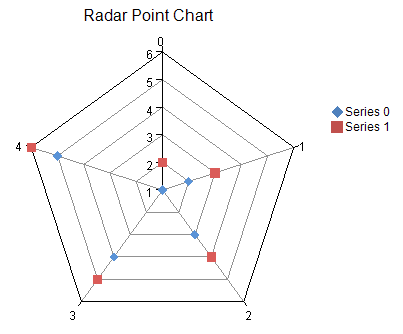
FarPoint.Web.Chart.RadarPointSeries series0 = new FarPoint.Web.Chart.RadarPointSeries();
series0.SeriesName = "Series 0";
series0.Values.Add(1.0);
series0.Values.Add(2.0);
series0.Values.Add(3.0);
series0.Values.Add(4.0);
series0.Values.Add(5.0);
FarPoint.Web.Chart.RadarPointSeries series1 = new FarPoint.Web.Chart.RadarPointSeries();
series1.SeriesName = "Series 1";
series1.Values.Add(2.0);
series1.Values.Add(3.0);
series1.Values.Add(4.0);
series1.Values.Add(5.0);
series1.Values.Add(6.0);
FarPoint.Web.Chart.RadarPlotArea plotArea = new FarPoint.Web.Chart.RadarPlotArea();
plotArea.Location = new System.Drawing.PointF(0.2f, 0.2f);
plotArea.Size = new System.Drawing.SizeF(0.6f, 0.6f);
plotArea.Series.Add(series0);
plotArea.Series.Add(series1);
FarPoint.Web.Chart.LabelArea label = new FarPoint.Web.Chart.LabelArea();
label.Text = "Radar Point Chart";
label.Location = new System.Drawing.PointF(0.5f, 0.02f);
label.AlignmentX = 0.5f;
label.AlignmentY = 0.0f;
FarPoint.Web.Chart.LegendArea legend = new FarPoint.Web.Chart.LegendArea();
legend.Location = new System.Drawing.PointF(0.98f, 0.5f);
legend.AlignmentX = 1.0f;
legend.AlignmentY = 0.5f;
FarPoint.Web.Chart.ChartModel model = new FarPoint.Web.Chart.ChartModel();
model.LabelAreas.Add(label);
model.LegendAreas.Add(legend);
model.PlotAreas.Add(plotArea);
FarPoint.Web.Spread.Chart.SpreadChart chart = new FarPoint.Web.Spread.Chart.SpreadChart();
chart.Model = model;
FpSpread1.Sheets[0].Charts.Add(chart);
Dim series0 As New FarPoint.Web.Chart.RadarPointSeries()
series0.SeriesName = "Series 0"
series0.Values.Add(1.0)
series0.Values.Add(2.0)
series0.Values.Add(3.0)
series0.Values.Add(4.0)
series0.Values.Add(5.0)
Dim series1 As New FarPoint.Web.Chart.RadarPointSeries()
series1.SeriesName = "Series 1"
series1.Values.Add(2.0)
series1.Values.Add(3.0)
series1.Values.Add(4.0)
series1.Values.Add(5.0)
series1.Values.Add(6.0)
Dim plotArea As New FarPoint.Web.Chart.RadarPlotArea()
plotArea.Location = New PointF(0.2F, 0.2F)
plotArea.Size = New SizeF(0.6F, 0.6F)
plotArea.Series.Add(series0)
plotArea.Series.Add(series1)
Dim label As New FarPoint.Web.Chart.LabelArea()
label.Text = "Radar Point Chart"
label.Location = New PointF(0.5F, 0.02F)
label.AlignmentX = 0.5F
label.AlignmentY = 0.0F
Dim legend As New FarPoint.Web.Chart.LegendArea()
legend.Location = New PointF(0.98F, 0.5F)
legend.AlignmentX = 1.0F
legend.AlignmentY = 0.5F
Dim model As New FarPoint.Web.Chart.ChartModel()
model.LabelAreas.Add(label)
model.LegendAreas.Add(legend)
model.PlotAreas.Add(plotArea)
Dim chart As New FarPoint.Web.Spread.Chart.SpreadChart()
chart.Model = model
FpSpread1.Sheets(0).Charts.Add(chart)
